
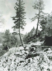
Bull Creek undercut the bank in many places, causing mature redwood to fall. Photograph courtesy Professor Paul Zinke.
In 1956, some of the tallest redwood trees in the world still stood in Rockefeller Grove in the Humboldt Redwood State Park, but more than a hundred had fallen the previous year, undercut by a raging Bull Creek, a tributary of the famed Eel River. The park service reacted by getting prisoners from a nearby state correctional institute to place rows of wire baskets along the tattered banks and then fill these containers with rocks. While work progressed, some called for the construction of a dam to prevent damage from future floods, although the amount and intensity of precipitation had not deviated much in a century. Others suggested an even more radical idea: to recruit scientists from the University of California at Berkeley to study the tolerance of redwood trees to floods and have them predict what would happen if flooding continued to increase or was reduced by construction of a dam.
A few years and another flood later, four professors and their graduate students—with me among the latter—examined the scene during the summer when Bull Creek was reduced to a few pools, linked by rivulets so shallow that children could safely cross. As we walked along the creek, we noted prison laborers replacing a broken section of a two-foot-thick wall of rock-filled wire baskets. To us, this effort seemed futile because the last flood carried debris so large that it easily battered through the artificial rampart, leaving a breach where torrents concentrated their force.
Two obvious questions were: How long had the trees stood along the river before they were washed away, and had conditions recently changed? In search of answer to these questions, we persuaded the park service to hire loggers to make fresh cuts across some of the large trees that had fallen recently, so we could see the rings of tissue of varying density that develop inside the truck each year as growing conditions change. The age of the trees can be determined by the number of these rings, and their widths provide an indication of the growing conditions during each season. It would have been laborious to count these rings in the field, so we took narrow strips of butcher’s paper, placed them over the roughened saw cut, and made “tree rubbings”, much the way that we might make impressions of plaques or coins. Each rubbing was labeled, then rolled and taken to the laboratory, where the total number and widths of annual rings could be easily measured. We discovered that trees were grouped into four different age classes: approximately 300, 850, 1,000, and 1,300 years old.
At a newly exposed wall of silt and gravel along the creek, we counted 15 separate layers of charcoal and dark stains of organic matter deposited over a depth of 30 feet. We collected samples of the charcoal and
carbon-14 dated them. The oldest charcoal matched the age of the oldest trees, 1,300 plus or minus 100 years. No wonder 300-foot-tall redwoods rarely succumb to wind and soggy substrate, their bases are buried from where they took root by 10 to 30 feet of alluvium!
But why were there only four age classes of trees when we could identify signs of fifteen separate floods? Seed production by redwood is prodigious; collections taken from hundreds of litter screens indicated that between eight and twelve million seeds per acre are produced annually. So there should always be seedlings that would lead to a continuous range of age classes.
To unravel this puzzle, we looked for an alluvial stand of younger redwoods, where the diameter of the trees were small enough to determine their ages from cores extracted with our 2-foot-long increment borers. At the nearby Stephen’s Grove, we found trees with accommodating dimensions. We determined the age of 50 trees of varying sizes and distances from the stand edge and found they had all established themselves after a flood that occurred during the U.S. Civil War (1860-1865). To determine heights, we recorded the angles to the top and base of each tree from a measured distance with a surveyor’s level. With this information, simple geometry allowed us to estimate tree height with accuracy of a few feet.
The point that emerged from our measurements was that trees farthest from the creek rarely exceeded 50 feet in height, whereas those nearest the edge of the grove were nearly three times taller. The tall trees at the edge intercept most of the light; we deduced that once a dense new stand is established, it effectively prevents more regeneration.
Floods that deposited two to four feet of silt or gravel didn’t seem to do the trees any harm. In fact, the width of the growth rings generally increased following most floods. Chemical analyses of the wood cores indicated that higher concentrations of zinc—an essential micronutrient—accumulates in growth rings following floods. But this was not the case recently; neither growth nor zinc concentrations had increased in the annual rings following the last two floods.
To determine how quickly a redwood tree’s roots can invade a fresh layer of silt, we contracted, with park service approval, a tractor operator to remove and then re-spread a two-foot layer of silt for 40 feet around four large trees. Over the next four years, we drove beveled pipes into the new silt deposits and extracted cores from which newly grown roots were washed, dried, and weighed. Within the first year, we found that new roots sprouted directly from the recently reburied portions of the stem and quickly grew to colonize about 30 percent of the new silt layer. Within three to four years, the live root mass was similar to what it had been before the tractor disturbed the silt, and none of the new growth rings in the trees decreased in width.
Professor Herbert Baker, a botanist, demonstrated that the ground vegetation—such as sword fern, fairy bels, and wood sorrel, which characterizes Rockefeller Grove and other floodplain forests—produced rhizomes that penetrate quickly through two feet of silt and spread laterally to reoccupy the fresh alluvium. None of the tree species or shrubs that occupy forested slopes above the floodplain survives burial. With periodic flooding, such species find refuge only on the moist surfaces of fallen trees.
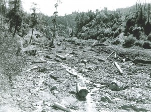
Soil damage caused by tractor logging outside the park led to massive erosion. Photograph courtesy Professor Paul Zinke.
All the evidence indicated that the characteristic open appearance of these “cathedral groves” is dependent on a fresh layer of sediment being deposited every 30 to 100 years. In the past, these layers were associated with fires in the surrounding uplands. The material deposited from recent floods, however, was deeper, less nutrient rich, and lacked charcoal, suggesting that erosion from the headwaters of Bull Creek was not the result of fire, as in the past, but from a different type of disturbance—tractor logging on steep slopes. The income received from timber taxes never came close to what it cost the county to repair roads and bridges or to compensate for irreversible damage incurred to the park downstream.
Massive amounts of silt eroded from upstream logging filled the streambed of Bull Creek causing excess water to carve new channels through redwood groves downstream. Photograph courtesy Professor Paul Zinke.
Additional insights about coastal redwood emerged from our investigations. These trees depend on heavy winter rains to create flooded conditions and Pacific Ocean fog to enable them to survive summer droughts. Where there is no fog, or winter rain is slight, other tree species compete with redwood and often replace it. Many answers to the park manager’s questions lay buried in the silt deposits from historic floods and in the growth rings of ancient trees.
Our research showed that periodic disturbances are required to maintain healthy redwood forests. The awe-inspiring cathedral groves, an image of permanence upon the landscape, would not persist, regenerate, or flourish without periodic floods—but floods with certain characteristics. From the investigation, we learned to take a broader view of the landscape, to distinguish present conditions from the past, and be careful with technological fixes designed to maintain ecological systems.
Thanks to Lise Waring for editing assistance.

 Soil damage caused by tractor logging outside the park led to massive erosion. Photograph courtesy Professor Paul Zinke.
 Massive amounts of silt eroded from upstream logging filled the streambed of Bull Creek causing excess water to carve new channels through redwood groves downstream. Photograph courtesy Professor Paul Zinke.